Albury to Bourke - Kidman Way.
Sun setting over the Bethanga Bridge, Albury.

Details

Open leg route
828.6KM / 514.9MI (Est. travel time 9 hours)

Drive straight through the middle of NSW, from the agricultural hub of Albury through friendly small towns, wine regions and national parks.

Finish your journey on the edge of the Outback in the iconic Darling River town of Bourke.
Open in mobile
1
Day 1: Albury

Begin your journey in this charming border town on the edge of the mighty Murray River, known for history, café culture and greenery.

Open in mobile
Murray River in Autumn from Noreuil Park, Albury. Photo by James Horan, Destination NSW
Dean Street, New South Wales, Australia, 2640
Get Directions
Albury boasts a thriving cultural scene, from festivals and exhibitions to markets, so check the events calendar before you arrive. Foodies will delight in exploring the cafes and restaurants.
Got a little more time? Try a spot of canoeing or take a peaceful riverside stroll along the Wagirra Trail.Before you depart for Griffith, visit the Murray Art Museum Albury and discover the Indigenous heritage at Mungabareena and Water Works.
Albury Visitor Information Centre
Albury, New South Wales, Australia, 2640
1300 252 879
info@visitalburywodonga.com
Get Directions
Caters for people who use a wheelchair., Wheelchair Access
Public Toilet
Public Toilet
WiFi
Parking
Caters for people who use a wheelchair., Wheelchair Access, Caters for people who use a wheelchair.

The Albury Visitor Information Centre is centrally located within the Albury LibraryMuseum. Be inspired by the welcoming team and pick up an Albury Wodonga guide.

Yackandandah Visitor Information Centre
Yackandandah, Victoria, Australia, 3749
(02) 6027 1988
info@exploreyackandandah.com.au
Get Directions

One of Australia's prettiest villages with a centre classified by the national trust, Yackandandah is nestled in the foothills of Stanley State Forest and steeped

Albury-Murray River PrecinctNoreuil Park
Albury-Murray River Precinct
South Albury, New South Wales, Australia
1300 252 879
Get Directions

Head down to the banks of the Murray River, between Albury and Woodonga, and stroll or cycle your way along the picturesque Wagirra Trail.

Altina Wildlife Park14432 Sturt Highway
14432, Sturt Highway, New South Wales, Australia, 2706
0412060342
Get Directions

This outstanding Wildlife Park has unique personalised Zoo-fari tours like no other.

This outstanding Wildlife Park has unique personalised Zoo-fari tours like no other. You will meet many Rare Exotic as well as some of Australia's Native animals up close and personal whilst travelling in style on Horse Drawn or Motorised Carts. The open-aired and leisurely feel of the tour will allow you to experience exciting new encounters as Altina's guides take you around the Park during the animal's daily feed times. The guided tours go for 2.5 hours on scheduled times. You must book ahead to avoid disappointment as spots can fill up fast for this experience of a lifetime. For the animal enthusiast you may like to try something a little more adventurous with the Behind the Scene Experiences where you feed and have the ultimate Altina encounter with your chosen animals.
Murray Art Museum Albury (MAMA)546 Dean Street
Murray Art Museum Albury
546, Dean Street, Albury, New South Wales, Australia, 2640
02 6043 5800
Get Directions

Visit MAMA for a contemporary art experience featuring a stunning 24-hour 'art skin', workshops and immersive experiences.

Mungabareena Reserve
Mungabareena and Water Works edit
East Albury, New South Wales, Australia
1300 252 879
Get Directions

Visit the spot where Aboriginal clans once met to trade and discover the reserve’s immense cultural significance for local clans.

2
Day 1: Jerilderie

Jerilderie is a charming riverside country town with a fascinating history and a starring role in the legend of bushranger Ned Kelly.

Open in mobile
Ned Kelly Blacksmith's Shop, Jerilderie. Photo by Murrumbidgee Council Visitor Information Centre
Newell Highway, Jerilderie, New South Wales, Australia, 2716
Arrive via car from Day 1: Jerilderie168KM / 104MI ~ Approximately 2 hours
Get Directions
First glance will reveal a splendid lake and rows of heritage buildings. However, make sure you delve into the rich history of this small town that was once raided by colonial bushranger Ned Kelly and his gang.
Perched on the banks of Billabong Creek, Jerilderie is a fertile farming area, producing myriad items including olives, tomatoes and organic wine grapes. It’s also home to fine merino wool and merino studs.
The Ned Kelly Raid Trail63 Jerilderie Street
Murrumbidgee Council Visitor Information Centre
63, Jerilderie Street, Jerilderie, New South Wales, Australia, 2716
(03) 5886 1200
Get Directions

Pick up a ‘raid trail’ map to stroll through the sites that Ned Kelly and gang visited during the famous 1879 raid on Jerilderie.

Pick up route map from Sticky Fingers Candy Shop
The Old Printery Building and the Bolt Exhibition39 Jerilderie Street
The Old Printery Building and The Bolt Exhibition
39, Jerilderie Street, Jerilderie, New South Wales, Australia, 2716
03 5886 1200
Get Directions

Head to the Old Printery, once Jelderie’s printing office where Ned Kelly tried to have his manifesto “The Jerilderie Letter” printed.

3
Day 1: Coleambally

Cruise through one of the youngest towns in NSW, in the centre of the vast Coleambally Irrigation Area of agriculture.

Open in mobile
Coleambally Water Tower. Photo by Murrumbidgee Council Visitor Information Centre
Brolga Place, New South Wales, Australia, 2707
Arrive via car from Day 1: Coleambally69KM / 43MI ~ Approximately 43 minutes
Get Directions
This warm and friendly rural town was only established in 1968, but it is still a tight-knit, welcoming community. The local industry centres on farming products including rice, wheat, barley, corn and olives.
Coleambally’s prominent water tower stands tall in the shape of a huge wine glass covered in a mosaic artwork which depicts the town’s history.
4
Day 2: Griffith

You’ve got a whole day to spend exploring this glorious European-inspired town, its blossoming wine region and nearby national park.

Open in mobile
Sun setting over Lake Wyangan, Griffith. Photo by Dee Kramer, Destination NSW
Jondaryan Avenue, New South Wales, Australia, 2680
Arrive via car from Day 2: Griffith65KM / 41MI ~ Approximately an hour
Get Directions
Settled by European migrants after WWI and WWII, Griffith boasts a rich Italian heritage and magnificent food and wine culture. In fact, one in four glasses of Australian wine are said to be produced in Griffith.
Take a post-breakfast stroll to admire the streets of Griffith, which was designed by famed architect Walter Burley Griffin in the early 20th century as part of the Murrumbidgee Irrigation Scheme. Then, enjoy a local bushwalk before venturing out to a winery for a tasting as the sun sets.
Griffith Tourism Hub
Griffith, New South Wales, Australia, 2680
1800 681 141
visitgriffith@griffith.com.au
Get Directions
Caters for people who are blind or have vision loss. Caters for people who use a wheelchair. Caters for people with sufficient mobility to climb a few steps but who would benefit from fixtures to aid balance. (This includes people using walking frames and mobility aids), Ambulant Access, Wheelchair Access
Ambulant Access, Public Toilet, Picnic Area
Picnic Area
Public Telephone, Public Toilet
WiFi
Parking, Coach Parking, Electric Vehicle Charging Point
Caters for people who are blind or have vision loss. Caters for people who use a wheelchair. Caters for people with sufficient mobility to climb a few steps but who would benefit from fixtures to aid balance. (This includes people using walking frames and mobility aids), Ambulant Access, Wheelchair Access, Caters for people who are blind or have vision loss. Caters for people who use a wheelchair. Caters for people with sufficient mobility to climb a few steps but who would benefit from fixtures to aid balance. (This includes people using walking frames and mobility aids)

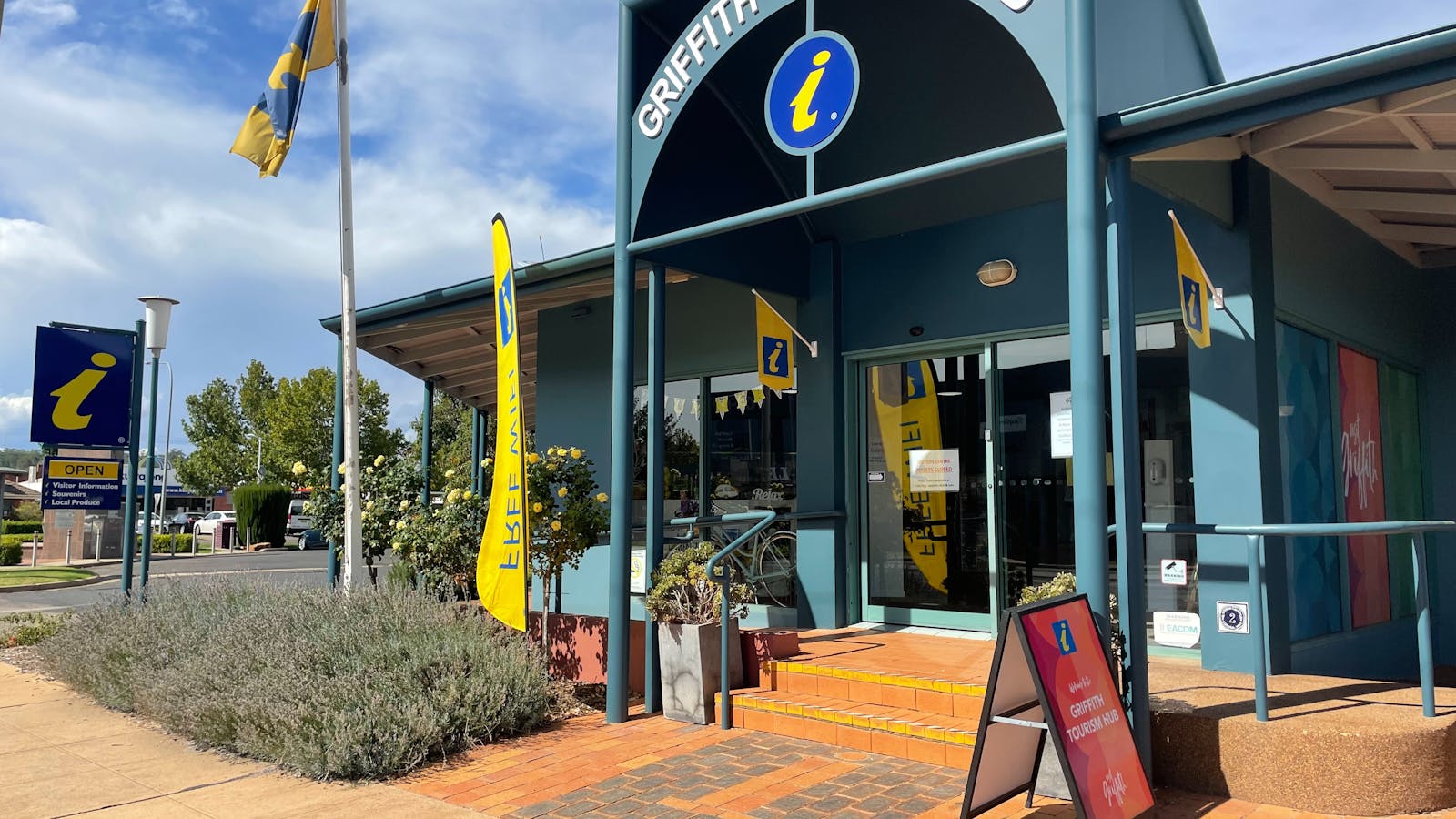
The Griffith Tourism Hub should be your first stop when visiting Griffith.

Bella Vita Tours1 Jondaryan Avenue
Bella Vita Tours
1, Jondaryan Avenue, Griffith, New South Wales, Australia, 2680
0437 927 651
Get Directions

Book a half-day tour with Bella Vita to get up close and personal with the lives and businesses of the Riverina community.

Falcon Falls Walking Track
John Spencer
Get Directions

Make your way into Cocoparra National Park for this 1.2km return track. Look out for the waterfalls and woodland birdlife.

Griffith Italian Museum
Paige Campbell
Remembrance Drive, New South Wales, Australia, 2680
02 6962 4196
Get Directions

This museum, on the grounds of the Pioneer Park Museum, tells the story of Griffith's early Italian settlers.

Calabria Family Wines1283 Brayne Road
Calabria Family Wines
1283, Brayne Road, Griffith, New South Wales, Australia, 2680
02 6969 0800
Get Directions

Indulge in a cellar door experience and be greeted at the Tuscan-style cellar door with deliciously warm Italian hospitality.

5
Day 3: Hillston

Admire the heritage buildings in Hillston, which serves as the perfect base to explore the Willandra National Park.

Open in mobile
Swing bridge over the Lachlan River in Hughie Cameron Park, Hillston. Photo by Dee Kramer, Destination NSW
Keats Street, Hillston, New South Wales, Australia, 2675
Arrive via car from Day 3: Hillston111KM / 69MI ~ Approximately an hour
Get Directions

Sights & Activities

Lachlan River Swing Bridge
Dee Kramer - Destination NSW
High Street, Hillston, New South Wales, Australia, 2675
Get Directions

Take a walk over the Lachlan River and explore the beautiful Australian bushland on the other side of the bridge.

6
Day 3: Cobar

Rich with mining heritage, Cobar sits at the crossroads of The Kidman Way and the Barrier Highway.

Open in mobile
Views over the open cut mine from Fort Bourke Hill viewing platform, Cobar. Photo by Dee Kramer, Destination NSW
Barton Street, Cobar, New South Wales, Australia, 2835
Arrive via car from Day 3: Cobar255KM / 158MI ~ Approximately 3 hours
Get Directions
Spend your afternoon at some of Cobar’s enormous open cut mines, such as Peak Hill Gold Mine, then delve into the town’s fascinating history as a mining centre by visiting a local museum.
Wander through the colonial buildings before venturing out to nearby Mount Grenfell to view Aboriginal rock art sites, stopping to take in the local wildlife on your way.
The Great Cobar Museum and Visitors Information Centre
Cobar Shire Council
Cobar, New South Wales, Australia, 2835
(02) 6836 5806
visitcobar@cobar.nsw.gov.au
Get Directions
Public Toilet, Picnic Area
Picnic Area
Public Toilet
Walks, WiFi
Parking, Coach Parking

Call into The Great Cobar Museum for information on Cobar and the surrounding area.

Fort Bourke Hill Lookout & Open Cut Mine
Cobar Visitor Information Centre
North Road, Cobar, New South Wales, Australia, 2835
02 6836 2448
Get Directions

See incredible views of Cobar. At Fort Bourke Hill Lookout take in the amazing view, and gaze into this huge open-cut mine.

Great Cobar Copper Mine
Great Cobar Heritage Centre
CSA Access Road, Cobar, New South Wales, Australia, 2835
Get Directions

Be awed by this large mine dating back to 1870. Check out how the huge smelters and a 64m chimney stack supplied energy.

Great Cobar Heritage Centre
Samantha Smith
02 6836 2448
Get Directions

Pick up a Heritage Walk flyer, then explore the centre’s extensive collection dating back to the early 1870s.

Peak Hill Open Cut Experience
Parkes Shire Council
02 6862 6000
Get Directions

See a modern-day working mine site. Visit the Peak viewing platform for an up-close view of the mine, then head to the ‘Golden Walk'.

7
Day 4: Bourke

Meander through this classic Aussie town, considered the last outpost before the Outback, that was once home to famed poet Henry Lawson.

Open in mobile
Sun rising over the Darling River and North Bourke Bridge, Bourke. Photo by Dee Kramer, Destination NSW
Mertin Street, Bourke, New South Wales, Australia, 2840
Arrive via car from Day 4: Bourke160KM / 100MI ~ Approximately 2 hours
Get Directions
Spend your final day exploring Bourke and enjoying the warm country hospitality of its locals. Gaze at the heritage buildings in town before heading out to explore with Bourke Indigenous Tours.
Then, hop on a paddle vessel with PV Jandra River Cruises or try the Bourke Town Trail. If you’re staying the night, savour the one-of-a-kind Poetry on a Plate experience.
Up for another adventure? Why not drive the Darling River Run to Broken Hill or take on the Star Gazing & Storytelling drive to Parkes.
Back Of Bourke Exhibition CentreBack O Bourke Exhibition Centre, Tancred Drive, Bourke, Bourke Shire Council, New South Wales, 2840, Australia
Back O Bourke Exhibition Centre
Back O Bourke Exhibition Centre,, Bourke, Bourke Shire Council, New South Wales, 2840, Australia, Tancred Drive
02 6872 1321
Get Directions

Learn about Henry Lawson’s ‘Outback’ and see interactive stories of the Inland Sea, then enjoy a coffee at the on-site cafe.

Bourke Indigenous Tours
Tancred Drive, Bourke, New South Wales, Australia, 2840
02 6872 1065
Get Directions

Uncover fascinating Aboriginal heritage. Make sure you have sturdy walking shoes for this 1.5-hour (rated easy) walking tour.

Bourke Town Trail
Bourke Town Trail
Oxley Street, Bourke, New South Wales, Australia, 2840
02 6872 1222
Get Directions

This trail will lead you to the Court House where bushranger Captain Starlight was committed for trial after his capture in 1868.

Gundabooka National Park
New South Wales, Australia
02 6830 0200
Get Directions

This beautiful park spans from the Darling River over Mount Gundabooka. Stretch out with a walk, then relax in the picnic area.

PV Jandra River Cruises
Dee Kramer - Destination NSW
02 6872 1321
Get Directions

The PV Jandra is an authentic reproduction of the original 1894 steam paddleboat that pulled a barge along the Darling River.

For ticketing and other information on the PV Jandra please call the Back O' Bourke Visitor Information Centre on (02) 6872 1321.
Poetry on a Plate
Dee Kramer - Destination NSW
Macquarie Street, New South Wales, Australia, 2840
0427 919 964
Get Directions

Enjoy a meal under a coolabah tree, warm up by a campfire and hear Australian poetry, local stories and music.

Using QR Codes

Open your Camera App or download a QR reader

Point your camera at the QR Code which will launch the correct app

Access websites and features such as maps and directions

Optional Downloads

GPX File

For use in apps such as GPS Navigation and wearable devices

KML File

For use in offline mapping products, such as maps.me and Google Maps

PDF File

A link to this document

Build your own itineraries

Alpaca provides a way for you to build your own itineraries. Visit https://alpaca.travel

Terms of Service and Attribution

Copyright Alpaca.travel, Mapbox.com and OpenStreetMaps openstreetmaps.com.
Terms of Service https://alpaca.travel/terms