Expert Guide to the Rainforest Way
Nightcap National Park - Lismore City Council

Details

Open leg route
462.8KM / 287.6MI (Est. travel time 7 hours)

There's no better way to explore the spectacular Gondwana Rainforests of Australia in northern NSW than by following the Rainforest Way.

Beginning in Byron Bay, this scenic driving loop will see you wind through a series of lush national parks as well as the quaint country towns and verdant farms that surround them. En route, you can enjoy breathtaking lookouts and exhilarating walks, discover unexpected arts scenes, learn about the region’s rich Aboriginal and colonial heritage, and tuck into hearty counter meals at heritage pubs – all at your own leisurely pace.
Open in mobile
1
Day 1: Byron Bay

Open in mobile
Visit the Cape Byron Lighthouse, Byron Bay
Get Directions
Start your journey in beautiful Byron Bay. Rise early to be among the first in Australia to watch the sun peek over the Pacific Ocean from the iconic Cape Byron Lighthouse, keeping your eye out for migrating whales between May and November, before fueling up with a hearty brunch at one of Byron’s many cafes. It’s just a short walk to Main Beach from the centre of town, with more surf beaches – including The Pass, Wategos and Tallow Beach – to the east.
After exploring the buzzy heart of town to the soundtrack of talented buskers, catch the Byron Solar Train to the Arts & Industry Estate for more shopping, an ever-increasing range of wellness options, and perhaps a brew at the Stone & Wood brewery or the Bucha Shed, Australia’s first alcoholic kombucha cellar door. Heading north towards Mullumbimby, The Farm is a great spot to stop for coffee, a delicious meal, and to learn about environmentally conscious farming.
Cape Byron Headland and Lighthouse
The Legendary Pacific Coast
Lighthouse Road, Byron Bay, New South Wales, Australia, 2481
(02) 6639 8300
npws.tweedbyron@environment.nsw.gov.au
Get Directions
Public Toilet, Picnic Area
Picnic Area, Barbeque
Public Toilet
Birdwatching, Walks
Parking

The Cape Byron Headland Reserve is a State Conservation Area managed by the NSW National Parks and Wildlife Service.

Wategos Beach
Marine Parade, Byron Bay, New South Wales, Australia, 2481
1300 072 757
parks.info@environment.nsw.gov.au
Get Directions
Non-smoking, Picnic Area
Picnic Area, Barbeque
Canoeing/Kayaking, Snorkelling, Surfing, Swimming
Parking

Located just north west of Cape Byron and the lighthouse, Wategos Beach is one of Byron’s best places to picnic, paddle and play.

The Farm Byron Bay
11 Ewingsdale Road, Byron Bay, New South Wales, Australia, 2481
Get Directions

Stone and Wood Brewery
4-6 Boronia Place, Byron Bay, New South Wales, Australia, 2481
(02) 6685 5173
Get Directions
Takeaway

The brewery combines the relaxed surf culture and community spirit of Byron Bay with a series of delicious, locally-sourced flavours and tastes.

2
Day 1: Mullumbimby

Open in mobile
Mural, Mullumbimby - Sarah Reid
Arrive via car from Day 1: Mullumbimby22KM / 14MI ~ Approximately 37 minutes
Get Directions
Heading north from Byron, take the scenic route through the coastal farmlands of Myocum to ‘Mullum’. Nestled beside the Brunswick River, near the foot of 309m Mount Chincogan, this timber industry settlement-turned alternative culture hub is home to some of the region’s best-preserved Federation-era buildings, many of which now house cafes, health food stores, and quirky boutiques.
Start your visit by exploring the centre of town, peeking down side alleys to admire colourful murals, before heading north on Dalley St, where you can enjoy a short bushwalk in the Brunswick Valley Heritage Park hugging the river. At the southern end of town, don’t miss the Mullumbimby Museum housed in the town’s first post office, built in 1907.
Mullum is also the jumping-off point for Goonengerry National Park to the south and Mount Jerusalem National Park to the north, both of which are set to receive infrastructure upgrades in the coming years.
When you’re ready to move on, head north on Coolamon Scenic Dr. If you have time to spare, make a short detour to explore the buzzy riverside town of Brunswick Heads en route to Murwillumbah, which has a fantastic bakery.
Brunswick Valley Historical Society Inc Museum and Park
BVHS Inc
Myokum Street, Mullumbimby, New South Wales, Australia, 2482
(02) 6684 4367
admin@mullumbimbymuseum.org.au
Get Directions
Caters for people with sufficient mobility to climb a few steps but who would benefit from fixtures to aid balance. (This includes people using walking frames and mobility aids) Caters for people who use a wheelchair., Ambulant Access, Wheelchair Access
Ambulant Access, Public Toilet, Non-smoking, Picnic Area
Picnic Area
Public Toilet
Walks
$1 ~ $2 AUD*
Parking
Caters for people with sufficient mobility to climb a few steps but who would benefit from fixtures to aid balance. (This includes people using walking frames and mobility aids) Caters for people who use a wheelchair., Ambulant Access, Wheelchair Access, Caters for people with sufficient mobility to climb a few steps but who would benefit from fixtures to aid balance. (This includes people using walking frames and mobility aids) Caters for people who use a wheelchair.
* A gold coin donation

The main museum building was Mullumbimby's first post office, built in timber in 1907, which was relocated to its present site in 1984.

3
Day 1: Murwillumbah

Open in mobile
Tweed River, Murwillumbah - Sarah Reid
Arrive via car from Day 1: Murwillumbah37KM / 23MI ~ Approximately 35 minutes
Get Directions
Heading north from Mullumbimby along Coolamon Scenic Dr, turn onto the Pacific Mwy and take the next exit at Yelgun. From here Tweed Valley Way winds through green pockets of coastal forest towards the sleepy country town of Murwillumbah. On the way, be sure to stop in at Tweed Valley Whey Farmhouse Cheeses just south of Burringbar for a decadent tasting, and in tiny Burringbar itself to admire its historic buildings.
Set alongside the Tweed River and surrounded by sugar cane fields and small farms, with the Tweed Range rising up to the west, old-fashioned ‘Murbah’ is best known for one of regional Australia’s finest art galleries – the Tweed Regional Gallery Margaret Olley Art Centre. Yet the town’s architectural charm is increasingly becoming a similarly compelling reason to visit. Many of Murbah’s art deco buildings have been restored in recent years, including Murwillumbah St’s iconic pink pub, the Imperial Hotel, which has a great bistro.
Tweed Regional Gallery and Margaret Olley Art Centre
Tweed Regional Gallery & Margaret Olley Art Centre
2 Mistral Road, South Murwillumbah, New South Wales, Australia, 2484
(02) 6670 2790
tweedart@tweed.nsw.gov.au
Get Directions
Caters for people who use a wheelchair. Caters for people with sufficient mobility to climb a few steps but who would benefit from fixtures to aid balance. (This includes people using walking frames and mobility aids), Ambulant Access, Wheelchair Access, Free Entry
Ambulant Access, Public Toilet, Non-smoking, Picnic Area
Picnic Area, Cafe
Public Toilet
Lookouts, WiFi
Parking, Coach Parking
Caters for people who use a wheelchair. Caters for people with sufficient mobility to climb a few steps but who would benefit from fixtures to aid balance. (This includes people using walking frames and mobility aids), Ambulant Access, Wheelchair Access, Caters for people who use a wheelchair. Caters for people with sufficient mobility to climb a few steps but who would benefit from fixtures to aid balance. (This includes people using walking frames and mobility aids)

Tweed Regional Gallery and Margaret Olley Art Centre is housed in a large, modern, architecturally award-winning building with views to Wollumbin/Mount Warning.

4
Day 1: Uki

Open in mobile
Scenic country views of Wollumbin (Mount Warning) in the Tweed Range
Arrive via car from Day 1: Uki16KM / 10MI ~ Approximately 17 minutes
Get Directions
You’ll enjoy superb views of 1,159m Wollumbin (formerly Mount Warning), the most distinctive feature of the Tweed Range, during the 14km drive from Murwillumbah to Wollumbin National Park. The road ends at the base of this volcanic plug, a remnant of the long-extinct Tweed Volcano, which has deep spiritual significance to the Bundjalung People of the Tweed Valley.
Nearby is Uki, a tiny, quirky village alongside the upper reaches of the Tweed River. Don’t miss its heritage-listed post office, which now doubles as the hip Bastion Lane coffee shop and roastery.
Mount Jerusalem National Park can also be accessed from Uki. If you’re travelling in a 4WD, consider making a side-trip into the park via Rowlands Creek Rd to seek out Unicorn Falls before making your way to Nimbin.
Lyrebird TrackLyrebird track
Mount Warning Road, Mount Warning, New South Wales, Australia, 2484
Get Directions
Walks, Hiking

Surround yourself with the lush subtropical rainforest of World Heritage-listed Wollumbin National Park by taking a short hike on Lyrebird track. Experience this beautiful Gondwana

Bastion Lane Espresso
1464 Kyogle Road, Uki, New South Wales, Australia, 2484
0402 469 807
gary@bastionlane.com
Get Directions
Takeaway

From the minute they fire up their La Marzocco, locals flock to Bastion Lane for their morning fix.

5
Day 2: Nimbin

Open in mobile
Walk the colourful streets of Nimbin - Lismore City Council
Arrive via car from Day 2: Nimbin55KM / 34MI ~ Approximately an hour
Get Directions
Instead of heading onward to Nimbin via pretty Kyogle Rd, which slices between Wollumbin National Park and Mount Jerusalem National Park, take the slightly longer route via Byrrill Creek Rd through Mebbin National Park. Make a stop at Cutters Creek campground to test your native birdwatching skills on the 1km-return Byrill Creek walking track. Be sure to keep an eye out for lace monitors and brush turkeys patrolling the forest floor.
If it’s a warm day you may wish to take a dip in Byrill Creek before continuing south into the lush Nimbin Valley to Australia’s capital of counter-culture.
Like most northern NSW hinterland towns, all the action happens on Nimbin’s main street. You’ll no doubt cross paths with some of its colourful characters as you browse local galleries and hippy boutiques including the iconic Hemp Embassy. Nimbin also makes a great base for exploring Nightcap National Park, particularly the gorgeous Protestors Falls walking track.
Passing through town towards Kyogle, you’ll spot the volcanic extrusions of rhyolite known as Nimbin Rocks rising up to the southwest. Like Wollumbin, this geological formation is both a remnant of the ancient Tweed Volcano and a significant cultural site to the Bundjalung People.
Byrrill Creek Walking Track
Photo: D Hofmeyer/NSW Government
Corner Cadell Road and Mebbin Forest Road, Mebbin, New South Wales, Australia, 2484
Get Directions
Walks, Hiking

This short walk starts at Cutters Camp campground’s picnic area and passes through sub-tropical rainforest with an impressive stand of giant, ancient fig trees, all

Cutters Camp CampgroundCutters Camp campground
Cutters Camp Road, Mebbin, New South Wales, Australia, 2484
1300 072 757
parks.info@environment.nsw.gov.au
Get Directions
5 rooms
Non-smoking
Barbeque
Cycling, Horse Riding
$12 ~ $36 AUD

Cutters Camp is a peaceful campground in a pretty forest setting with a large, free-form area. It's popular with families, birdwatchers and bushwalkers alike

Protesters Falls Walking Track
Nightcap National Park
Terania Creek Road, Nightcap, New South Wales, Australia, 2480
Get Directions
Walks, Hiking

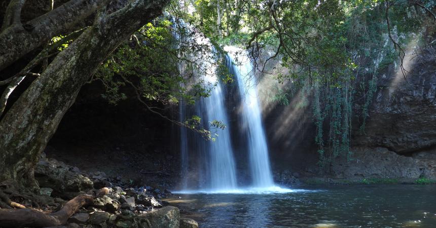
Nestled in the rugged ranges of Nightcap National Park, World Heritage-listed Protestors Falls walking track leads through magnificent rainforest to a spectacular waterfall. An ideal

Nimbin Rocks
Lismore and Nimbin Tourism
Nimbin Road, Nimbin, New South Wales, Australia, 2480
tourism@lismore.nsw.gov.au
Get Directions
Free Entry
Parking

The Nimbin Rocks are volcanic extrusions of Rhyolite left over from the Mount Warning Tweed Volcano that erupted around 20 million years ago.

6
Day 2: Kyogle

Open in mobile
Captain Cook Lookout in Kyogle - Sarah Reid
Arrive via car from Day 2: Kyogle32KM / 20MI ~ Approximately 28 minutes
Get Directions
The lush hills of Nimbin give way to undulating cattle pastures dotted with more geological relics as you near the sleepy country town of Kyogle. Founded as a lumber camp in the 1830s, Kyogle’s main street is still lined with art deco buildings constructed during its dairy industry boom years.
The first decision you’ll need to make in Kyogle is whether to stop for a drink or a meal at the ‘Top Pub’ (The Commercial Hotel) or at the ‘Bottom Pub’ (The Exchange Hotel).
Kyogle is perfectly positioned for exploring several nearby national parks, notably Border Ranges National Park and Toonumbar National Park to the northwest, both of which have impressive lookouts, excellent walking loops, and scenic campgrounds.
Don’t leave town without soaking up the views over town towards the Border Ranges from the Captain Cook Memorial Lookout on a hill southeast of the centre on Fairy Mount. If you’re lucky, you might be joined by a kangaroo or two up here.
Border Ranges National Park
Gradys Creek Road, Cougal, New South Wales, Australia, 2474
1300 072 757
parks.info@environment.nsw.gov.au
Get Directions
Non-smoking, Picnic Area
Picnic Area
Camping, Walks, Hiking, Lookouts

World Heritage-listed Border Ranges National Park near Murwillumbah, offers walking, cycling, drive touring, school excursion options, camping and scenic views.

Toonumbar National Park
OEH
Murray Scrub Road, Toonumbar, New South Wales, Australia, 2474
1300 072 757
parks.info@environment.nsw.gov.au
Get Directions
Non-smoking, Picnic Area
Picnic Area
Camping, Walks, Lookouts

World Heritage-listed Toonumbar National Parks in Northern NSW, offers outstanding walking tracks, horse riding, picnic areas near Kyogle.

7
Day 2: Tooloom National Park

Open in mobile
Tooloom National Park Walking Track - Sarah Reid
Arrive via car from Day 2: Tooloom National Park100KM / 62MI ~ Approximately an hour
Get Directions
Enjoy more spectacular northern NSW landscapes by taking a scenic detour northwest of Kyogle, visiting Tooloom National Park to the west before looping back to Casino via Tabulam. When you reach Woodenbong, head south on Clarence Way until you reach the cute village of Urbenville, home to the Pioneer Cottage Museum and the picturesque Tooloom Falls campground.
From here it’s a one-hour return drive to the Tooloom National Park picnic area and its lush 1km rainforest walking loop. Continue south from Urbenville on Clarence Way towards tiny Tabulam on the east bank of the Clarence River before travelling onto Casino.

Sights & Activities

Tooloom Walking TrackTooloom walking track
Tooloom Road, Upper Tooloom, New South Wales, Australia, 2475
Get Directions
Walks, Hiking

Tooloom walking track takes you on a short, easy walk a little deeper into the lush rainforest of Tooloom Scrub, which is part of Gondwana

8
Day 2: Casino (via Tabulam)

Open in mobile
The Richmond River flowing through the North Coast town of Casino
Arrive via car from Day 2: Casino (via Tabulam)138KM / 86MI ~ Approximately 2 hours
Get Directions
Hit the road en route to the Beef Capital of Australia. You’ll be travelling through the cattle farms that gave this large rural town its nickname. There are plenty of attractions worth seeking out within its broad streets including several museums, a bounty of art deco buildings, and new art gallery set to take over the Roads and Traffic Authority building on Barker St.
If you time your visit with Casino Beef Week in May, you'll find the town bursting with people keen to enjoy the cattle competitions, rodeo, markets and gala events.
If you’re wondering what this farming town has to do with the rainforest, look to the west. Rising up beyond golden pastures, Richmond Range National Park makes for an excellent day trip. Don’t miss the spectacular views towards Wollumbin from the Mallanganee Lookout near the entrance to Cambridge Plateau scenic drive (a dirt road best suited to higher-clearance vehicles), which winds its way into the rainforest.
Richmond Range National Park
Cambridge Plateau Road, Peacock Creek, New South Wales, Australia, 2469
1300 072 757
parks.info@environment.nsw.gov.au
Get Directions
Non-smoking, Picnic Area
Picnic Area
Four Wheel Driving, Camping, Scenic Drives, Walks, Lookouts

Richmond Range National Park offers rainforest walks, tranquil campgrounds, and scenic views along horse trails, near Kyogle, in northern New South Wales. You'll find an

Mallanganee Lookout
Bruxner Highway, Mallanganee, New South Wales, Australia, 2469
(02) 6632 0000
visitkyogle@kyogle.nsw.gov.au
Get Directions
Free Entry
Birdwatching, Walks, Hiking, Lookouts
Parking

Situated on the peak of the Richmond Range is the spectacular Mallanganee Lookout. Located approximately 40 minutes west of Casino, just off the Bruxner Highway.

9
Day 2: Lismore & Nightcap National Park

Open in mobile
Aerial overlooking Minyon Falls in Nightcap National Park, Whian Whian
Arrive via car from Day 2: Lismore & Nightcap National Park31KM / 19MI ~ Approximately 25 minutes
Get Directions
The largest regional centre in the Northern Rivers, Lismore has enjoyed something of a cultural renaissance in recent years, with highlights of its thriving arts scene including the Lismore Regional Gallery, theatre company NORPA, the Back Alley Gallery, and the Arts, Vintage and Retro Trail.
But while it’s easy to get caught up in Lismore’s arts and increasingly vibrant culinary scene, one of the city’s best features is its proximity to Nightcap National Park.
The region’s most popular national park, Nightcap’s defining feature is the spectacular Minyon Falls, which cascades 100m into the subtropical rainforest below. There are viewpoints next to and opposite the falls, but to enjoy the full Minyon experience, hiking to the base of the falls is a must.
Intersecting the park from west to east, the 18km Historic Nightcap walking track follows a route once used by postal workers making their way between Lismore and Murwillumbah, ending at the Minyon Falls lookout. Nearby Rocky Creek Dam offers another beautiful setting for a picnic, with the added bonus of potential platypus sightings from a purpose-built platform.
Nightcap National Park
Nightcap, NSW, Australia
Get Directions

Minyon Falls LookoutMinyon Falls
Lismore, NSW, Australia, 2480
Get Directions

Rocky Creek Dam
Lismore, NSW, Australia, 2480
Get Directions

Arts, Vintage and Retro Trail
207 Molesworth Street, Lismore, New South Wales, Australia, 2480
Get Directions

Lismore Regional Gallery
11 Rural Street, Lismore, New South Wales, Australia, 2480
(02) 6622 2209
art.gallery@lismore.nsw.gov.au
Get Directions
Caters for people with sufficient mobility to climb a few steps but who would benefit from fixtures to aid balance. (This includes people using walking frames and mobility aids) Caters for people who use a wheelchair. Caters for people with high support needs who travel with a support person. Caters for people who are deaf or have hearing loss., Ambulant Access, Wheelchair Access, Free Entry
Ambulant Access, Public Toilet
Cafe
Public Toilet
WiFi
Parking
Caters for people with sufficient mobility to climb a few steps but who would benefit from fixtures to aid balance. (This includes people using walking frames and mobility aids) Caters for people who use a wheelchair. Caters for people with high support needs who travel with a support person. Caters for people who are deaf or have hearing loss., Ambulant Access, Wheelchair Access, Accessible for Hearing Impairment, Catering for High Support, Caters for people with sufficient mobility to climb a few steps but who would benefit from fixtures to aid balance. (This includes people using walking frames and mobility aids) Caters for people who use a wheelchair. Caters for people with high support needs who travel with a support person. Caters for people who are deaf or have hearing loss.

Lismore Regional Gallery presents energetic and thought provoking exhibitions and events for the enjoyment of locals and visitors. The Lismore Gallery's collection features significant Australian

10
Day 2: Newrybar

Open in mobile
Killen Falls in Newrybar - Sarah Reid
Arrive via car from Day 2: Newrybar26KM / 16MI ~ Approximately 30 minutes
Get Directions
Departing Minyon Falls lookout bound for Newrybar, you’ll soon pass through the blink-and-you’ll-miss-it village of Federal, where renowned Japanese fusion bistro Doma makes a great lunch stop. From here it’s a winding but gorgeous journey through macadamia plantations and other small produce farms towards the tiny hamlet of Newrybar.
Hugging a tiny arc of road off Hinterland Way, Newrybar is home to some of the Byron hinterland’s best boutiques as well as the award-winning Harvest Newrybar restaurant and deli, where you can also grab a coffee and baked goods to go. This hip little village lies close to Killen Falls, one of the hinterland’s most accessible waterfalls, and the serene Gaia Retreat & Spa, which is co-owned by Olivia Newton-John.
Federal Doma Cafe
6 Albert Street, Federal, New South Wales, Australia, 2480
(02) 6688 4711
Get Directions
Japanese, Takeaway
Live Music

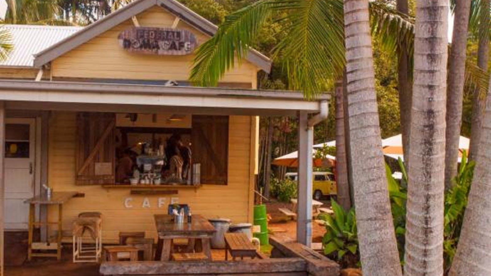
Since opening in September 2012, it has become a magnet for locals, day-trippers, and people travelling through the hinterland en route to Nimbin or Lismore.

Harvest Newrybar
Destination NSW
22 Old Pacific Highway, Newrybar, New South Wales, Australia, 2479
(02) 6687 2644
goodtimes@harvest.com.au
Get Directions
Australian, Modern Australian, Dinner, Lunch, Private Dining, Takeaway
WiFi
Parking

A short ride from Byron Bay, Harvest Newrybar restaurant, bakery and deli showcase the diversity of the wonderful local region.

Gaia Retreat and Spa
933 Fernleigh Road, Brooklet, New South Wales, Australia, 2479
(02) 6687 1216
info@gaiaretreat.com.au
Get Directions
22 rooms
Laundry Facilities, Non-smoking, Swimming Pool
Fireplace
Swimming, Walks, Day Spa Facility, Tennis Pool, Games or Recreation Room, Spa/Sauna, WiFi
$1350 ~ $12254 AUD*
Parking
* Retreat stay packages start from two nights and are subject to change and availability.

Gaia ... the spirit of Mother Earth. Nestled amongst green valleys and undulating hills in the subtropical Byron Bay hinterland near Bangalow, Gaia Retreat and

11
Day 2: Bangalow

Open in mobile
Main Street, Bangalow - Sarah Reid
Arrive via car from Day 2: Bangalow5KM / 3MI ~ Approximately 5 minutes
Get Directions
It’s just a short hop north along Hinterland Way to the trendy farming town of Bangalow. With its main street lined by Federation-era buildings housing cafes and boutiques, this hinterland hot spot has long-been popular with Byron Bay-based day trippers. Newer developments include the independent fashion precinct off Station St anchored by sunny plant-based cafe Woods, sister-cafe to Byron’s Folk.
At the southern entrance to town, the historic Bangalow Hotel will satisfy pub grub cravings, while at the northern end, the Bangalow Bowlo is another popular spot to relax over a casual meal or a game of barefoot bowls.
Tucked behind the main drag, you can also enjoy a taste of history – and homebaked goods – at the Bangalow Heritage House and Museum. It sits beside Bangalow Parklands, which makes a great picnic spot.
Instead of heading back to Byron via the Pacific Hwy, enjoy one last country drive along achingly scenic Bangalow Rd, which offers glimpses of Byron on the 20min drive back to the centre of town, ending your Rainforest Way adventure.

Sights & Activities

Bangalow Hotel
1 Byron Street, Bangalow, New South Wales, Australia, 2479
(02) 6687 1314
info@bangalowhotel.com.au
Get Directions
Australian, Modern Australian
Entertainment, Live Music

Bangalow Hotel was built in the early 1940's and situated in the heart of Bangalow village.

Using QR Codes

Open your Camera App or download a QR reader

Point your camera at the QR Code which will launch the correct app

Access websites and features such as maps and directions

Optional Downloads

GPX File

For use in apps such as GPS Navigation and wearable devices

KML File

For use in offline mapping products, such as maps.me and Google Maps

PDF File

A link to this document

Build your own itineraries

Alpaca provides a way for you to build your own itineraries. Visit https://alpaca.travel

Terms of Service and Attribution

Copyright Alpaca.travel, Mapbox.com and OpenStreetMaps openstreetmaps.com.
Terms of Service https://alpaca.travel/terms