Rainforest Way.
Couple at Protesters Falls, Nightcap National Park, Northern Rivers. Image: The Legendary Pacific Coast

Details

Open leg route
223.9KM / 139.1MI (Est. travel time 3 hours)

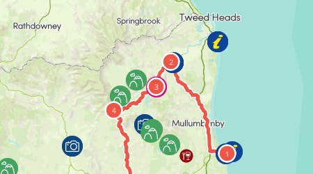
There are multiple scenic drives that will take you through the Gondwana Rainforests of Australia World Heritage Area of northern NSW.

You can tour spectacular rainforests by exploring these suggested areas at your own pace.
Open in mobile
1
Byron Bay

This route from Byron Bay offers incredible hinterland views of the coast on the way to the the rainforests of northern NSW.

Open in mobile
Cape Byron Lighthouse, Byron Bay.
Marvell Street, Byron Bay, New South Wales, Australia, 2481
Get Directions
Take a side trip to the village of Federal, as you head towards Nightcap National Park. The magnificent Minyon Falls area has a picnic spot with views and walks, where you can marvel at the precipitous falls and ancient World-heritage listed rainforest.
Byron Visitor Centre
Mick Webb
Byron Bay, New South Wales, Australia, 2481
(02) 6680 8558
info@visitbyronbay.com
Get Directions
Public Toilet, Picnic Area
Picnic Area
Public Toilet
WiFi
Parking

Call into the Byron Visitor Centre for information on Byron Bay and the surrounding area. The friendly staff can provide you with a range of

Cape Byron Information Centre
DPIE
Byron Bay, New South Wales, Australia, 2481
(02) 6639 8300
npws.tweedbyron@environment.nsw.gov.au
Get Directions
Public Toilet
Public Toilet
Parking

When visiting the beautiful NSW North Coast, get your holiday off to a great start with a visit to Cape Byron Information Centre.

Federal
Visit NSW
Australia, 2480
Get Directions

Wind through the village of Federal, home to renowned Doma Cafe which could provide sustenance for hiking at Minyon Falls, on Minyon Falls Road within Nightcap National Park.
Minyon Falls
Get Directions

From this spectacular lookout, watch the cascades flow over Minyon Falls to a deep palm-shaded gorge below.

2
Murwillumbah

On the banks of the beautiful Tweed River and near World Heritage rainforest, Murwillumbah is a great base for exploring.

Open in mobile
View of Mount Warning (Wollumbin) peak, Mt Warning National Park, Murwillumbah district.
Wollumbin Street, New South Wales, Australia, 2484
Arrive via car from Murwillumbah52KM / 32MI ~ Approximately 43 minutes
Get Directions
Visit the World Heritage Rainforest Centre at the Murwillumbah Visitor Information Centre and learn the story of Wollumbin (Mount Warning) and collect maps and information before heading out to explore this very scenic region.
Follow the Tourist Drive 32 to Wollumbin (Mt Warning), around the crater of this extinct volcano now carpeted with rich farmlands and enchanting rainforest. In the World Heritage-listed Wollumbin National Park you will love the exhilarating walking trails under rainforest canopy.
11km further along, on the banks of the beautiful Tweed River, Uki is a charming village on the Rainforest Way touring route with spectacular views. On the third Sunday of the month is the Uki Buttery Bazaar, a village market with local arts and crafts and delicious food.
Continue from Uki on Kyogle Road for about 7km, turning right onto Byrrill Creek. This winding country route contains 10km of unsealed road. Travel 35km and take the entrance to Mebbin National Park, on Mebbin Forest Road on the left. Enjoy the Byrill Creek Walking Track through sub-tropical rainforest and ancient fig trees.
Murwillumbah Visitor Information Centre
Ryan Fowler Photography
South Murwillumbah, New South Wales, Australia, 2484
(02) 6672 1340
murwillumbah@thetweed.com.au
Get Directions
Caters for people who use a wheelchair., Wheelchair Access
Public Toilet
Public Toilet
Parking, Coach Parking
Caters for people who use a wheelchair., Wheelchair Access, Caters for people who use a wheelchair.

The Murwillumbah Visitor Information Centre operated by Tweed Tourism Company is located just before the bridge entry to Murwillumbah's CBD.

Kingscliff Visitor Information Centre
Kingscliff, New South Wales, Australia, 2487
(02) 6674 8064
info@thetweed.com.au
Get Directions
Public Toilet
Public Toilet

Call in for local area information with friendly staff and volunteers with suggestions on things to do and see and provide you with maps.

3
Uki

For breathtaking views of Mount Warning, visit the village of Uki on the doorstep of World Heritage rainforest in Wollumbin National Park.

Open in mobile
Uki, near Wollumbin-Mt Warning.
Kyogle Road, New South Wales, Australia, 2484
Arrive via car from Uki14KM / 8MI ~ Approximately 13 minutes
Get Directions
Murwillumbah Visitor Information Centre
Ryan Fowler Photography
South Murwillumbah, New South Wales, Australia, 2484
(02) 6672 1340
murwillumbah@thetweed.com.au
Get Directions
Caters for people who use a wheelchair., Wheelchair Access
Public Toilet
Public Toilet
Parking, Coach Parking
Caters for people who use a wheelchair., Wheelchair Access, Caters for people who use a wheelchair.

The Murwillumbah Visitor Information Centre operated by Tweed Tourism Company is located just before the bridge entry to Murwillumbah's CBD.

Kingscliff Visitor Information Centre
Kingscliff, New South Wales, Australia, 2487
(02) 6674 8064
info@thetweed.com.au
Get Directions
Public Toilet
Public Toilet

Call in for local area information with friendly staff and volunteers with suggestions on things to do and see and provide you with maps.

Uki Buttery Bazaar1454 Kyogle Road
Byron Visitor Information Centre
1454, Kyogle Road, Uki, New South Wales, Australia, 2484
02 6679 5921
Get Directions

Enjoy a scrumptious lunch at these markets or just mellow out under the riverside trees with a quality beverage from 'coffee oasis'.

Wollumbin - Mount WarningWollumbin National Park, Caldera Road, Mount Warning, Tweed Shire Council, New South Wales, 2484, Australia
S Foreman, Office of Environment and Heritage
Wollumbin National Park,, Mount Warning, Tweed Shire Council, New South Wales, 2484, Australia, Caldera Road
02 6670 8600
Get Directions

World-Heritage-listed Wollumbin National Park is a great place to walk or picnic and is home to an important cultural landmark, Wollumbin - Mount Warning.
4
Mebbin National Park

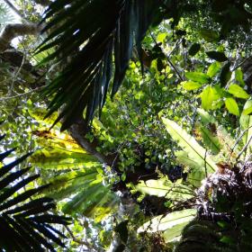
Near Murwillumbah and Tweed Heads, Mebbin National Park is a paradise for nature-lovers and a significant nature conservation area.

Open in mobile
Byrrill Creek walking track, Mebbin National Park. Photo: D Hofmeyer and OEH
Cadell Road, New South Wales, Australia, 2484
Arrive via car from Mebbin National Park25KM / 15MI ~ Approximately 27 minutes
Get Directions
Murwillumbah Visitor Information Centre
Ryan Fowler Photography
South Murwillumbah, New South Wales, Australia, 2484
(02) 6672 1340
murwillumbah@thetweed.com.au
Get Directions
Caters for people who use a wheelchair., Wheelchair Access
Public Toilet
Public Toilet
Parking, Coach Parking
Caters for people who use a wheelchair., Wheelchair Access, Caters for people who use a wheelchair.

The Murwillumbah Visitor Information Centre operated by Tweed Tourism Company is located just before the bridge entry to Murwillumbah's CBD.

Byrrill Creek Walking Track
D Hofmeyer, NSW Government
Mebbin Forest Road, New South Wales, Australia, 2484
Get Directions

This short walk starts at Cutters Camp campground’s picnic area and passes through sub-tropical rainforest with an impressive stand of giant, ancient fig trees, all the way down to the peaceful and scenic Byrrill Creek.
Kyogle
NPWS
Summerland Way, New South Wales, Australia, 2474
Get Directions

Called the Gateway to the Rainforests, Kyogle is by the meandering Richmond River at the base of Fairy Mountain in the Lismore region.
Visit the Kyogle Visitor Information Centre to learn more about Border Ranges and pick up a brochure. Border Ranges National Park is 31km north of Kyogle.
Mount Nardi Picnic Area
John Spencer, Office of Environment and Heritage
Newton Drive, New South Wales, Australia, 2480
Get Directions

Surrounded by rainforest in Nightcap National Park, Mount Nardi picnic area is a birdwatching haven and the starting point for many exhilarating walking tracks.
Nightcap National ParkNightcap National Park, Protestors Falls Track, Nightcap, Tuntable Falls, Lismore City Council, New South Wales, 2480, Australia
Hamilton Lund, Office of Environment and Heritage
Get Directions

national park in New South Wales, Australia

Explore ancient World Heritage-listed rainforests of Nightcap National Park, where you’ll find great campgrounds, picnic areas, walks and stunning views.
Protesters Falls
The Legendary Pacific Coast
Get Directions

Located in World Heritage Nightcap National Park, Protesters Falls is a must see while exploring the Lismore Hinterland.

5
Lismore

Along with a number of art galleries, theatres and markets, Lismore is a great base for exploring Nightcap National Park.

Open in mobile
Campground at Nightcap National Park. Photo: John Spencer OEH
Dawson Street, New South Wales, Australia, 2480
Arrive via car from Lismore48KM / 30MI ~ Approximately an hour
Get Directions
You will also find the surrounding area rich with scenic hinterland, arty villages and picturesque country drives.
Consider making a stop at Protesters Falls, named after the logging protests of the 1970s that saved this precious patch of rainforest and and walking to a cascading waterfall to enjoy splendid views from Mount Nardi picnic area.
The nearby village of The Channon comes alive on the second Sunday of each month with the not-to-be-missed craft market that’s been operating for over 40 years.
Another great side-trip from Lismore is via Bentley Road, or the scenic route along Nimbin Road, north to Kyogle, on the meandering Richmond River at the base of Fairy Mountain.
You will find many opportunities to explore untouched wilderness in this part of the Gondwana Rainforests of Australia World Heritage Area.
Casino Visitor Information Centre
Casino, New South Wales, Australia, 2470
(02) 6660 0325
tourism@richmondvalley.nsw.gov.au
Get Directions
Caters for people with sufficient mobility to climb a few steps but who would benefit from fixtures to aid balance. (This includes people using walking frames and mobility aids) Caters for people who use a wheelchair. Caters for people with high support needs who travel with a support person. Caters for people who are deaf or have hearing loss., Ambulant Access, Wheelchair Access
Ambulant Access, Public Toilet
Public Toilet
WiFi
Parking
Caters for people with sufficient mobility to climb a few steps but who would benefit from fixtures to aid balance. (This includes people using walking frames and mobility aids) Caters for people who use a wheelchair. Caters for people with high support needs who travel with a support person. Caters for people who are deaf or have hearing loss., Ambulant Access, Wheelchair Access, Accessible for Hearing Impairment, Catering for High Support, Caters for people with sufficient mobility to climb a few steps but who would benefit from fixtures to aid balance. (This includes people using walking frames and mobility aids) Caters for people who use a wheelchair. Caters for people with high support needs who travel with a support person. Caters for people who are deaf or have hearing loss.

The Casino Visitor Information Centre provides a diverse range of information and assistance to locals and tourists travelling throughout the area.

Ballina Visitor Information Centre
Ballina, New South Wales, Australia, 2478
1800 777 666
discover@ballina.nsw.gov.au
Get Directions
Caters for people with sufficient mobility to climb a few steps but who would benefit from fixtures to aid balance. (This includes people using walking frames and mobility aids), Ambulant Access
Ambulant Access, Public Toilet
Public Toilet
Parking
Caters for people with sufficient mobility to climb a few steps but who would benefit from fixtures to aid balance. (This includes people using walking frames and mobility aids), Ambulant Access, Caters for people with sufficient mobility to climb a few steps but who would benefit from fixtures to aid balance. (This includes people using walking frames and mobility aids)

Make the most of your stay in beautiful Ballina Shire and drop in to the award-winning Ballina Visitor Information Centre.

6
Casino

Explore charming villages and spectacular rainforests west of Casino, taking in historic towns and significant indigenous sites.

Open in mobile
The Boer War Memorial in Casino.
Canterbury Street, New South Wales, Australia, 2470
Arrive via car from Casino31KM / 19MI ~ Approximately 24 minutes
Get Directions
Travelling west on the Bruxner Highway towards Tabulam, stop on the way at Mallanganee lookout for tremendous views over the Richmond Range.
Continuing onwards, take an optional detour and turn right at the historic bridge onto Tabulam Road. This route takes you through Jacksons Flat to pretty Bonalbo, an historic cedar getting town.
There’s also an option to continue north via Urbanville, situated in the headwaters of the mighty Clarence River with fishing, fossicking and canoeing activities, and Woodenbong, nestled in volcanic country with spectacular mountain scenery and on to Kyogle before looping back to Casino to make for a full day’s drive.
Casino Visitor Information Centre
Casino, New South Wales, Australia, 2470
(02) 6660 0325
tourism@richmondvalley.nsw.gov.au
Get Directions
Caters for people with sufficient mobility to climb a few steps but who would benefit from fixtures to aid balance. (This includes people using walking frames and mobility aids) Caters for people who use a wheelchair. Caters for people with high support needs who travel with a support person. Caters for people who are deaf or have hearing loss., Ambulant Access, Wheelchair Access
Ambulant Access, Public Toilet
Public Toilet
WiFi
Parking
Caters for people with sufficient mobility to climb a few steps but who would benefit from fixtures to aid balance. (This includes people using walking frames and mobility aids) Caters for people who use a wheelchair. Caters for people with high support needs who travel with a support person. Caters for people who are deaf or have hearing loss., Ambulant Access, Wheelchair Access, Accessible for Hearing Impairment, Catering for High Support, Caters for people with sufficient mobility to climb a few steps but who would benefit from fixtures to aid balance. (This includes people using walking frames and mobility aids) Caters for people who use a wheelchair. Caters for people with high support needs who travel with a support person. Caters for people who are deaf or have hearing loss.

The Casino Visitor Information Centre provides a diverse range of information and assistance to locals and tourists travelling throughout the area.

Mallanganee Lookout
Get Directions

Situated on the peak of the Richmond Range is the spectacular Mallanganee Lookout.

Located approximately 40 minutes west of Casino, just off the Bruxner Highway.
7
Tabulam

Options in this area include stunning Yabbra State Forest and Tooloom Falls in Tooloom National Park.

Open in mobile
Tooloom walking track, Tooloom Nature reserve. Photo: David Young and OEH
Bruxner Highway, Tabulam, New South Wales, Australia, 2469
Arrive via car from Tabulam56KM / 35MI ~ Approximately 36 minutes
Get Directions
Tooloom National Park is just under two hours' drive north of Tabulam and part of the Gondwana Rainforest of Australia World Heritage Area.
This idyllic spot has great opportunities for walking, picnicking and birdwatching. You will also be treated to scenic views of the Great Dividing Range.
Richmond Ranges
Cambridge Plateau Forest Drive, New South Wales, Australia, 2470
Get Directions

Richmond Range National Park offers rainforest walks, tranquil campgrounds, and scenic views along horse trails.

Tooloom National Park
David Young, Office of Environment and Heritage
New South Wales, Australia
Get Directions

Tooloom National Park, in Gondwana Rainforest of Australia World Heritage Area, is a great place for walking, picnicking, birdwatching and scenic views to the Great Dividing Range.

Using QR Codes

Open your Camera App or download a QR reader

Point your camera at the QR Code which will launch the correct app

Access websites and features such as maps and directions

Optional Downloads

GPX File

For use in apps such as GPS Navigation and wearable devices

KML File

For use in offline mapping products, such as maps.me and Google Maps

PDF File

A link to this document

Build your own itineraries

Alpaca provides a way for you to build your own itineraries. Visit https://alpaca.travel

Terms of Service and Attribution

Copyright Alpaca.travel, Mapbox.com and OpenStreetMaps openstreetmaps.com.
Terms of Service https://alpaca.travel/terms